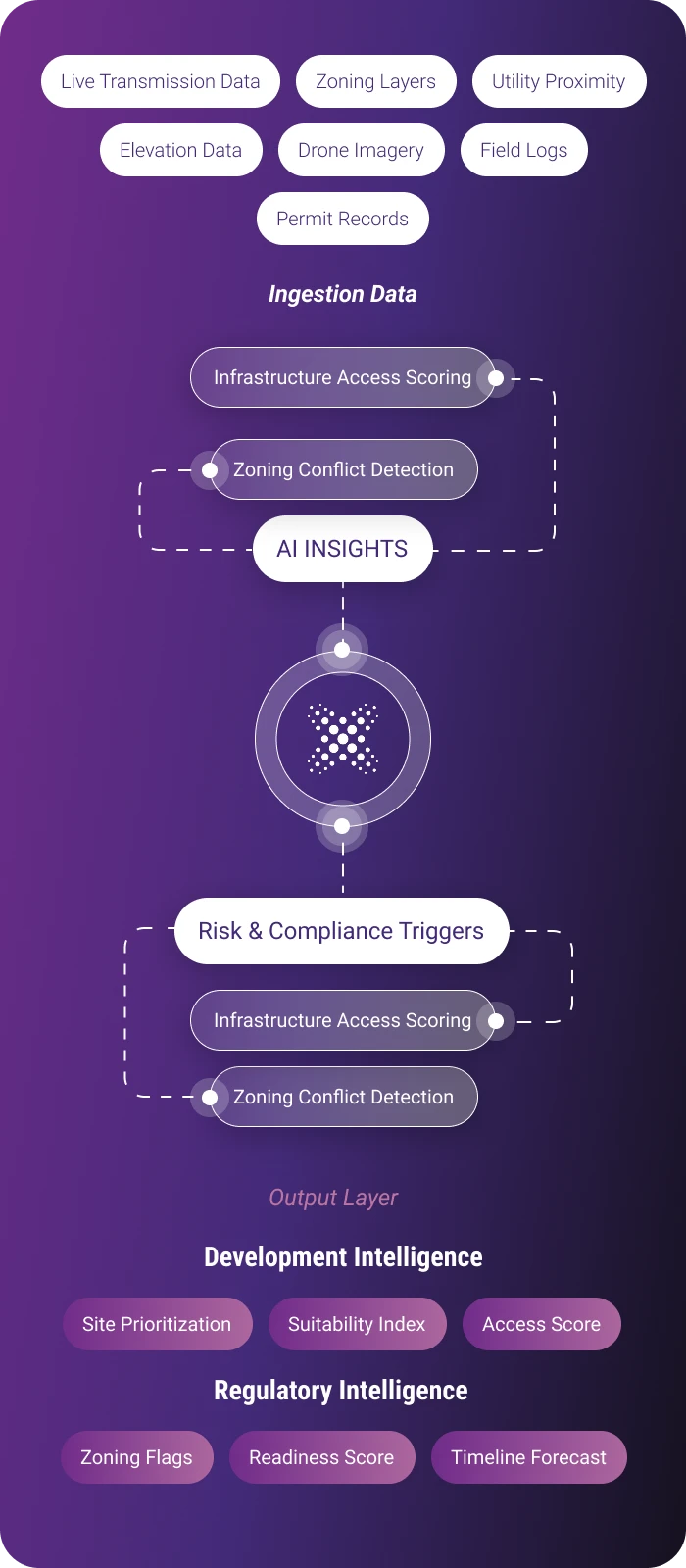
Transforming Land Layers intoPlanning Intelligence
DeepMatrix connects parcel maps, zoning overlays, utility proximity, and field data into an AI-powered system that delivers clear priorities, risk alerts, and permit readiness, all in one continuous decision loop.

Real-world results from DeepMatrix deployments show measurable gains in system accuracy, zoning efficiency, and planning speed, all backed by operational metrics and institutional alignment.
Verified Outcomes.Quantified Impact.
68%
(Measured through zoning conflict flags and resolution workflows)Reduction in Permit Disputes
DeepMatrix minimizes errors by resolving zoning mismatches and land-use overlaps before submission, cutting conflict resolution time.
75%
(Measured across registry sync and geospatial-layer alignment)Reduction in Material Losses
With unified overlays and live sync to municipal systems, DeepMatrix boosts matching accuracy between planning records and civic databases.
82%
(Measured through zoning overlay compliance accuracy)Reduction in Routing Conflicts
By automatically cross-referencing development routes with zoning overlays, DeepMatrix significantly reduces encroachment errors, access violations, and rework.
3x
(Measured by submission-to-clearance cycles)Acceleration in Planning Approvals
AI-assisted document preparation and conflict pre-screening streamline submission workflows, enabling faster approvals across departments and jurisdictions.
Interlinked Systems.Integrated Intelligence.
DeepMatrix unifies zoning, permit, and civic datasets into a synchronized system, accelerating approvals, reducing planning conflicts, and streamlining multi- agency coordination.

Real-time visibility into approval and disposition status
Permit Disposition
Intelligence
DeepMatrix integrates planning records and field data to dynamically flag pending, approved, or disposed parcels. This enables faster decision-making, eliminates overlaps, and streamlines coordination across civic and zoning agencies.
Elevation-Aware Built
Form Analysis
High-accuracy 3D mesh models enable volumetric checks for height limits, FSI adherence, and shadow impact. DeepMatrix flags deviations pre-submission, reducing zoning conflicts and speeding up approvals.

3D Mesh Intelligence for Urban Planning
From conflict detection to compliance workflows, DeepMatrix connects the field, system, and authority in a single
planning view.
Built to Integrate.
Designed for Governance.

Constraint-Aware Planning
Zoning and
Regulatory Overlay
DeepMatrix fuses zoning constraints, municipal overlays, and cadastral boundaries into a single decision layer. This enables automated compliance checks, eliminates conflicting parcel usage, and validates regulatory feasibility across urban and peri-urban zones.

Submission Pathway Intelligence
Permit & Compliance Mapping
DeepMatrix structures approval flows by linking permit dependencies, authority zones, and required clearances. This ensures early identification of bottlenecks, improves submission timing, and drives faster civic alignment through AI-mapped regulatory pathways.

AI Risk Forecasting
Scenario-Based Risk Modeling
DeepMatrix maps land use decisions against policy, environmental, and operational timelines to model potential risks. By simulating project pathways, it flags delays, overlaps, and revision triggers, enabling planners to adapt early and reduce downstream disruptions.
Multi-Source Data Normalization
Harmonizes unstructured civic data, from handwritten records to outdated registries, into usable digital layers.
Legacy System Compatibility
Integrates with existing municipal software, GIS systems, and planning databases without requiring system overhaul.
Jurisdiction-Aware Submission
Maps approval pathways across federal, state, and local bodies, aligning documentation with zonal regulations.
Local Governance Logic
Adapts workflows for regional differences in zoning rules, planning hierarchies, and civic authority structures.
Let’s schedule a walkthrough tailored to your land records, zoning plans, infrastructure stages, and compliance workflows.
We’ll align a session with your use case, whether it’s digitizing land records, managing urban growth, or monitoring rural infrastructure.